Old map of the Holy Land  by Gerard and Cornelis de Jode
Scroll to zoom, click for slideshow

Old map of the Holy Land 1593

Gerard and Cornelis de Jode

PaperPrint
33 ⨯ 51 cm
€ 3.750

Inter-Antiquariaat Mefferdt & De Jonge

  • About the artwork
    16TH CENTURY PICTORAL MAP OF THE HOLY LAND “Descriptio et Situs Terrae Sanctae alio Nomine Palestina, Multis Preclaris Historys et Miraculis utriusque testamenti a Christo Salvatore nobilitata.” [The description and location of the Holy Land also called Palestine, famed for the many illustrious histories and miracles of both Testaments by Christ the Saviour.] Copper engraving published in 1593 by Gerard and Cornelis de Jode in the “Speculum Orbis Terrarum”. Coloured by a later hand. Size: 33,9 x 51,4 cm. The map shows the Holy Land oriented to the east, with its coastline from Tyrus to Gaza. The events of the Bible are depicted in words and illustrations. It locates the Twelve Tribes, the descendants of the biblical patriarch Jacob, who collectively form the Israelite nation. Gerard de Jode states in the tekst box in the lower left: Here you find, good reader, a compendious description of the entire land of promise from the book of Joshua and Ezekiel, indicating the regions, cities, mountains, and monuments worthy of being known, both old and new. The De Jode family (Gerardus, the father, and Cornelis, the son) from Antwerp, had the misfortune of attempting to compete in the atlas market with the formidable and well-connected Abraham Ortelius. The De Jodes were and are respected as mapmakers, as evidenced by this work based on then current sources, but they were no commercial match for Ortelius. They published a mere two editions of their atlas as opposed to approximately 40 by Ortelius. Hence, the considerable rarity of De Jode maps in today’s market. This map of the Holy land appeared in only the second edition of De Jode’s atlas, and is consequently even rarer. Price: Euro 3.750,-
  • About the artist

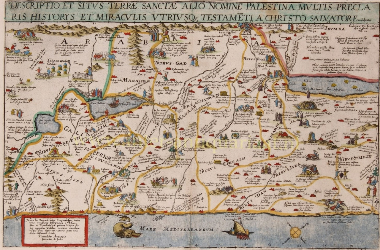
    Cornelis de Jode (Antwerp, 1568 – Bergen, 1600) was a South Netherlandish cartographer, engraver and printer. Cornelis was a son of Gerard de Jode.

    He had prepared himself for his task through study and distinguished himself as a 'plaetsnyder' and publisher. De Jode soon had success: the second edition of the world atlas Speculum Orbis Terrarum ('Mirror of the countries of the world') by his father Gerard, now renamed as Speculum Orbis Terrae ('Mirror of the world country'), improved and enlarged from 65 to 109 cards, appeared in 1593 and sold much better than the first. In 1595 Cornelis joined the Antwerp Guild of Saint Luke of artisans.

    De Jode also wrote De Quadrante Geometrico Libellus (1594), 'Book about the geometric quadrant'. According to his epitaph, Cornelis was one of the rather rare cartographers who had traveled extensively: to Norway, Denmark, Iceland, Italy and Spain.

    An untimely death ended his promising career. The copper plates came into the possession of the publisher J.B. Vrients who also bought Ortelius' plates. However, no similar atlas editions by Vrients are known, only a reissue of the Pool map in 1618.

Are you interested in buying this artwork?