Old map of the Holy Land  by Gerard and Cornelis de Jode
Scroll to zoom, click for slideshow

Old map of the Holy Land 1593

Gerard and Cornelis de Jode

PapelImprimir
33 ⨯ 51 cm
€ 3.750

Inter-Antiquariaat Mefferdt & De Jonge

  • Sobre arte
    16TH CENTURY PICTORAL MAP OF THE HOLY LAND “Descriptio et Situs Terrae Sanctae alio Nomine Palestina, Multis Preclaris Historys et Miraculis utriusque testamenti a Christo Salvatore nobilitata.” [The description and location of the Holy Land also called Palestine, famed for the many illustrious histories and miracles of both Testaments by Christ the Saviour.] Copper engraving published in 1593 by Gerard and Cornelis de Jode in the “Speculum Orbis Terrarum”. Coloured by a later hand. Size: 33,9 x 51,4 cm. The map shows the Holy Land oriented to the east, with its coastline from Tyrus to Gaza. The events of the Bible are depicted in words and illustrations. It locates the Twelve Tribes, the descendants of the biblical patriarch Jacob, who collectively form the Israelite nation. Gerard de Jode states in the tekst box in the lower left: Here you find, good reader, a compendious description of the entire land of promise from the book of Joshua and Ezekiel, indicating the regions, cities, mountains, and monuments worthy of being known, both old and new. The De Jode family (Gerardus, the father, and Cornelis, the son) from Antwerp, had the misfortune of attempting to compete in the atlas market with the formidable and well-connected Abraham Ortelius. The De Jodes were and are respected as mapmakers, as evidenced by this work based on then current sources, but they were no commercial match for Ortelius. They published a mere two editions of their atlas as opposed to approximately 40 by Ortelius. Hence, the considerable rarity of De Jode maps in today’s market. This map of the Holy land appeared in only the second edition of De Jode’s atlas, and is consequently even rarer. Price: Euro 3.750,-
  • Sobre artista

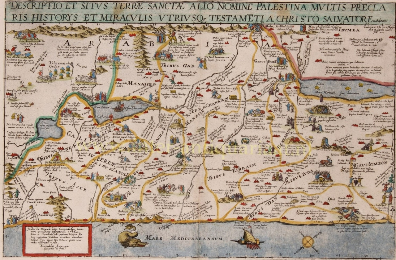
    Cornelis de Jode (Antuérpia, 1568 – Bergen, 1600) foi um cartógrafo, gravador e impressor sul-neerlandês. Cornelis era filho de Gerard de Jode.

    Ele se preparou para sua tarefa por meio do estudo e se destacou como 'plaetsnyder' e editor. De Jode logo teve sucesso: a segunda edição do atlas mundial Speculum Orbis Terrarum ('Espelho dos países do mundo') por seu pai Gerard, agora renomeado como Speculum Orbis Terrae ('Espelho do país do mundo'), melhorou e ampliado de 65 para 109 cartões, apareceu em 1593 e vendeu muito melhor que o primeiro. Em 1595, Cornelis ingressou na Guilda de Antuérpia de São Lucas de artesãos.

    De Jode também escreveu De Quadrante Geometrico Libellus (1594), 'Livro sobre o quadrante geométrico'. De acordo com seu epitáfio, Cornelis foi um dos raros cartógrafos que viajou extensivamente: para a Noruega, Dinamarca, Islândia, Itália e Espanha.

    Uma morte prematura encerrou sua promissora carreira. As placas de cobre passaram para a posse do editor J.B. Clientes que também compraram as placas de Ortelius. No entanto, nenhuma edição de atlas semelhante por Vrients é conhecida, apenas uma reedição do mapa Pool em 1618.

Você está interessado em comprar esta obra de arte?