VIEW OF 17TH CENTURY AMSTERDAM 1650
Caspar Merian
CartaStampa
19 ⨯ 70 cm
€ 1.250
Inter-Antiquariaat Mefferdt & De Jonge
- A proposito di opere d'arte
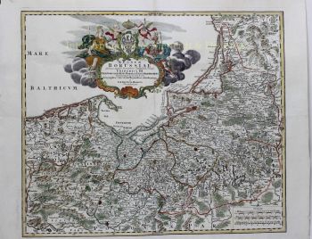
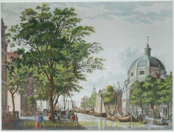
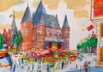
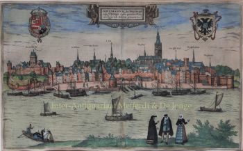
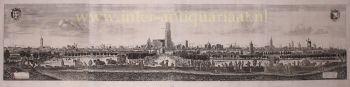
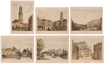
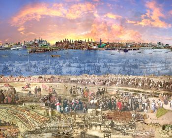
VIEW OF 17TH CENTURY AMSTERDAM "Amsterdam", engraving printed from two copperplates, made around 1650, published in Frankfurt am Main by Caspar Merian in 1659. Coloured by a later hand. Size: 19.5 × 70.5 cm. From the Topographia Germaniae Inferioris. From left to right one can distinguish the Rijzenhoofd, the Antoniespoort, the West India warehouse, the Montelsbaanstoren, Zuiderkerk tower, Munttoren, and Schreierstoren, the Walloon Church, Sint-Olofskapel,(Chapel of St. Olaf), the Old Church, the Nieuwezijds Kapel, the stock exchange, the Waag, the old Town Hall with its pointed tower, the Nieuwe Kerk with its completed tower, the Jan Rodenpoort tower, Haringpakkers tower, and Wester tower, the Noorderkerk, the Bickers tower, and the Haarlemmerpoort. The city’s grain warehouses are also depicted; the old Town Hall had not yet burned down (1652). Topographia Germaniae Inferioris was part of the Topographia Germaniae, the most important work of engraver and publisher Matthäus Merian the Elder (1593–1650). He published this monumental work together with Martin Zeiler (1589–1661) of Ulm, who was responsible for the text. The work contains around 2,000 illustrations and plans of towns, monasteries, and castles and is considered one of the most significant achievements in the field of topographical illustration. Merian had begun in 1642 with the publication of a survey of town views, landscapes, and maps, for which he had been collecting drawings for decades. Up to 1688 the series was expanded with further descriptions of European regions, ultimately reaching 30 volumes with a total of 92 maps and 2,142 town views, making it one of the largest publications of its time. The first volumes were engraved and published by Matthäus Merian himself. Later, much of the engraving work was commissioned from several prominent engravers of the day, while his sons Matthäus the Younger and Caspar took over the publishing activities. Price: Euro 1.250,-
- A proposito di opere artista
Caspar Merian (1627–1686) fu un importante incisore topografico, cartografo ed editore svizzero-tedesco che svolse un ruolo chiave nel perpetuare una delle più influenti dinastie editoriali del XVII secolo. Nato nella rinomata famiglia Merian, era figlio di Matthäus Merian il Vecchio, la cui bottega a Francoforte era diventata un centro di riferimento per libri e mappe illustrate in Europa.Caspar Merian (1627–1686) fu un importante incisore topografico, cartografo ed editore svizzero-tedesco che svolse un ruolo chiave nel perpetuare una delle più influenti dinastie editoriali del XVII secolo. Nato nella rinomata famiglia Merian, era figlio di Matthäus Merian il Vecchio, la cui bottega a Francoforte era diventata un centro di riferimento per libri e mappe illustrate in Europa.
Insieme al fratello, Matthäus Merian il Giovane, Caspar rilevò la casa editrice di famiglia a Francoforte, consolidandone ulteriormente la reputazione per la qualità delle sue opere topografiche e storiche. Le loro pubblicazioni combinavano un'accurata ricostruzione geografica con una ricca narrazione visiva, contribuendo in modo significativo alla diffusione della conoscenza delle regioni e delle città europee.
Tra le loro opere più importanti si annoverano i volumi della serie Topographia, tra cui Topographia Germaniae Inferioris vel Circuli Burgundici, che offriva descrizioni dettagliate e incisioni delle principali città e regioni delle Diciassette Province (i Paesi Bassi). Contribuirono inoltre alla continuazione del monumentale Theatrum Europaeum, un'ampia cronaca degli eventi politici e militari europei.
Più avanti nella vita, a causa di problemi di salute, Caspar Merian si trasferì da Francoforte a Wertheim nel 1672 e successivamente in Frisia nel 1677, dove entrò a far parte della comunità religiosa labadista. Nonostante questi successivi spostamenti, la sua opera rimase profondamente influente. Attraverso le sue incisioni e pubblicazioni, Caspar Merian contribuì a plasmare la cartografia e la rappresentazione topografica dell'Europa moderna, preservando ed estendendo l'eredità della casa editrice Merian.
Sei interessato ad acquistare questa opera d'arte?
Artwork details
Related artworks
Artista Sconosciuto
Baroque Iberian Emerald Earrings, 18th Century Goldwork with 58 Emeralds1750
€ 7.250Adin Fine Antique Jewellery
A cura diDanny Bree
Artista Sconosciuto
Dutch School pair of equestrian paintings 1650 - 1750
Prezzo su richiestaGallerease Selected
1 - 4 / 24Rene Rietmeyer
"Germany, Saarland, April 2001"2001
Prezzo su richiestaEuropean Cultural Centre Collection
1 - 4 / 24Johannes Christiaan Karel Klinkenberg
Cityscape Amsterdam1875 - 1925
Prezzo su richiestaGalerie Gabriëls
Cornelis Vreedenburgh
Oudezijds Achterburgwal te Amsterdam1920 - 1940
Prezzo su richiestaBruning Heintz Fine Art
Willem Alexander Knip
Prinseneiland in de winter1920 - 1930
Prezzo su richiestaBruning Heintz Fine Art
Nicolaas van der Waay
Stadhouderskade met Rijksmuseum1880 - 1900
Prezzo su richiestaBruning Heintz Fine Art
Gerard Johan Staller
Joodse markt aan de Oudeschans in Amsterdam1900 - 1930
Prezzo su richiestaBruning Heintz Fine Art
1 - 4 / 24Dean West
Charras de Agua Santa, TX (Emily Rivera) #1, American West 20262026
Prezzo su richiestaARTITLEDcontemporary
1 - 4 / 24- 1 - 4 / 12


![RARE ARMORIAL MAP: LEO BRABANTIAE Lion of the most noble Duchy of Brabant] by Sibertus Waterloos](https://media-3.gallerease.com/images/325cc033-a3b6-495f-9da8-6d06caf29b14/350x350/rare-armorial-map-leo-brabantiae-lion-of-the-most-noble-duchy-of-brabant.jpg)


