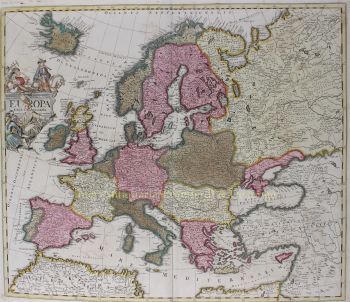
Johann Baptist Homann (1664–1724) fu un importante cartografo, incisore ed editore tedesco dell'inizio del XVIII secolo, ampiamente considerato uno dei cartografi più influenti del suo tempo. Nato a Oberkammlach, in Baviera, frequentò inizialmente una scuola gesuita prima di convertirsi al protestantesimo, una decisione che avrebbe plasmato sia il suo percorso personale che professionale.Johann Baptist Homann (1664–1724) fu un importante cartografo, incisore ed editore tedesco dell'inizio del XVIII secolo, ampiamente considerato uno dei cartografi più influenti del suo tempo. Nato a Oberkammlach, in Baviera, frequentò inizialmente una scuola gesuita prima di convertirsi al protestantesimo, una decisione che avrebbe plasmato sia il suo percorso personale che professionale.
Homann iniziò la sua carriera come notaio a Norimberga nel 1687, ma ben presto si dedicò all'incisione e alla cartografia, spinto da un crescente interesse per la geografia e la rappresentazione visiva della conoscenza. Dopo un periodo formativo a Vienna tra il 1693 e il 1695, tornò a Norimberga, dove fondò la sua casa editrice nel 1702. Questo segnò l'inizio di una carriera estremamente produttiva e influente.
Le sue mappe si distinsero rapidamente per la precisione, la chiarezza e la ricchezza decorativa, combinando il rigore scientifico con elaborate ornamentazioni barocche. La reputazione di Homann gli valse la nomina a Geografo Imperiale da parte dell'imperatore Carlo VI nel 1715, e in seguito fu eletto membro dell'Accademia Prussiana delle Scienze di Berlino, un riconoscimento del suo contributo al progresso delle conoscenze geografiche.
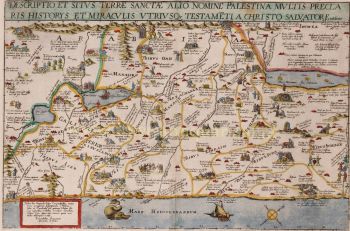
Nel 1716, Homann pubblicò la sua opera più celebre, il Grosser Atlas über die ganze Welt (Grande Atlante del Mondo), una raccolta completa e ambiziosa di mappe che consolidò la sua eredità. Molte di queste opere furono realizzate in collaborazione con l'incisore Christoph Weigel il Vecchio. Attraverso la sua casa editrice e la sua produzione cartografica, Homann svolse un ruolo centrale nell'affermare Norimberga come importante centro di produzione cartografica in Europa.