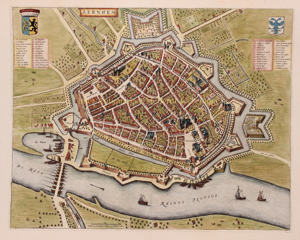
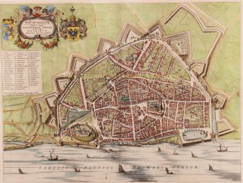
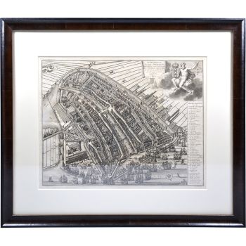
PLATTEGROND OF 17E-EEU ARNHEM "Aernhem", copper engraving by Joan Blaeu, as part of his "Toonneel der Steden", published in 1649 in Amsterdam. Later hand-coloured. Verso: Latin text. Sizes: 41 x 52,5 cm. The map was not drawn by Joan Blaeu, but by the cartographer Nicolaes van Geelkercken in 1639. Van Geelkercken received the commission for this from the Arnhem city council in 1638. The map thus reflects the situation around 1639. Van Geelkercken's design is not only found in this edition by Blaeu, but the printers Johannes Janssonius and Frederik de Wit also published variations on the map. Blaeu describes the city as follows: Arnhem is the capital of the Veluwe and seat of the highest court of the Duchy of Gelre. The city is "mighty, glorious, strong and rich in citizens". The Rhine flows along the city wall and the air is good because of the surrounding forests. In the surrounding area, the citizens have pleasant courtyards and gardens. On the side of the Veluwe, in the direction of Maastricht, there is a hill outside the city, "from the welcke sich a lustige aenschouwing over de naeste landen van de Betuwe vert vert vert". North of the town are hills and valleys planted with woods and heathland, where various kinds of wild animals are hunted. There is also the Wildhaen, once the hunting ground of the dukes, now "very useful for a walk for the citizens". To the south of the town, on the other side of the Rhine, are the beautiful fields of the Betuwe, where many oats, barley, peas, beans and other grain crops grow. Against "the violence from outside" the city has five "as strong as a castle" gates (four are made of stone). Of these, St. John's Gate was built in 1537 by Charles of Gelre, who feared the arrival of Charles V. Blaeu writes about the nature of the citizens that they are "courteous and lovers of science, and many live there from noble families". They are also heroic. Think of the city of Neuss that was helped by the citizens of Arnhemm during the siege by Charles the Bold. They also provided help during the terrible fire of Harderwijk in 1503. The city has a chapter of canons [in the St. Walburgis church], a Franciscan monastery [Broeren church on the map] and an Agnietenklooster [which passed into the hands of the St. Catharina Gasthuis in 1636]. The Commanderij van Sint-Jan is home to the Hospitaller knights, who used to collect a toll at the Janspoort on goods imported from the Veluwe, until this privilege was bought off by the bishop of Utrecht. In the Grote Kerk, with its beautiful tower, Duke Charles of Gelre is buried "in the inner court, of carved marble". See here for a nice animation of 17th century Arnhem. Price: Euro 750,-