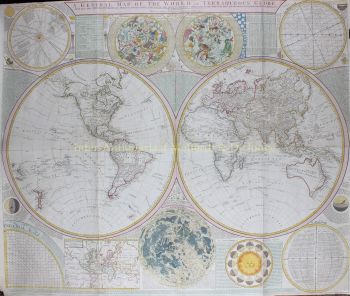
mappa del mondo 1745
Covens and Mortier
€ 2.250
Inter-Antiquariaat Mefferdt & De Jonge
- A proposito di opere d'arteMappe-Monde Dressé sur les Observations de Mrs. De L'Academie Royale des Sciences et quelques autres et sur les memoires les plus recens Par M. De L'Isle. Copper engraving published by Covens & Mortier in Amsterdam 1745. Coloured by a later hand. Size: 50,8 x 63,5 cm. Guillaume De L'Isle's world map was originally published in 1700 and then revised and republished throughout the 18th century by De L'Isle and by subsequent map publishers. Dutch publishers Covens & Mortier's first version of De L'Isle's map was produced in 1720 adding the seascape with ships on the horizon at the bottom decorated with a second cartouche in the shape of a sea monster with a mermaid, merman and dolphins. They issued a later edition of that map (shown here) in about 1745 with the additional subtitle "Nouvellement corrigée apres les dernieres Decouvertes faites par l'Academie de Petersbough." The map consists of two central hemispheres, eastern and western, surrounded by four smaller polar projections. The right hand projections focus on the Northern Hemisphere while the left hand projections depict the Southern. At top center there is an elaborate decorative cartouche with various allegorical elements depicting the four great continents in female form, from top left: America, Europa, Africa, and Asia. The routes of a number of the most famous explorers of the major oceans of the world are shown from 1542 to approximately 1730, ending with the Russian voyages of Chirikov and Bering. Some of the more noteworthy features of the map includes the Russian explorations along the Northwestern coast of America, Aleutian islands shown in a semi-mythical configuration and attached to a highly conjectural Alaska; Edmund Halley's sighting of Antarctic ice; Bouvet's large Cap de la Circoncision; A depiction of the tracks of François Pelsaert's route from Australia to Java; Carpentaria attached to New Guinea; Abel Tasman's route, along with a depiction of Tasmania, distinctly separate from Australia. The map also retains one of the more curious peninsula depictions of California. Price: Euro2.250,-
- A proposito di opere artista
Covens and Mortier (1721 - c. 1862) era una casa editrice di Amsterdam, successore del vasto impero editoriale costruito da Pierre Mortier (1661 - 1711).
Le mappe di Covens e Mortier sono spesso criticate come derivate, ma non è del tutto vero. Pierre Mortier visse a Parigi dal 1681 al 1685. Lì stabilì stretti rapporti con i più grandi cartografi francesi dell'epoca, tra cui De L'Isle e D'Anville.
Il suo modello di business si basava sullo sfruttamento della tecnologia e della raffinatezza della stampa olandese per co-pubblicare cartografia francese all'avanguardia. Alla morte di Mortier nel 1711 la sua azienda fu rilevata dal figlio, Cornelius Mortier (1699 - 1783). Cornelius sposò la sorella di Johannes Covens (1697 - 1774) nel 1721 e, in collaborazione con suo cognato, fondò lo studio Covens and Mortier.
Sotto l'impronta di Covens e Mortier, Cornelius e Johannes continuarono nel modello di Pierre di pubblicare le opere francesi più aggiornate con il permesso. Divennero rapidamente una delle più grandi e prolifiche aziende editoriali olandesi del XVIII secolo.
L'azienda ei suoi successori hanno pubblicato migliaia di mappe in un periodo di 120 anni dal 1721 alla metà del 1800. Durante la loro lunga vita la ditta Covens and Mortier pubblicò come Covens and Mortier (1721 - 1778), J. Covens and Son (1778 - 94) e Mortier, Covens and Son (1794 - c. 1862).
Sei interessato ad acquistare questa opera d'arte?
Artwork details
Related artworks
- 1 - 4 / 7
- 1 - 4 / 24
- 1 - 4 / 12


