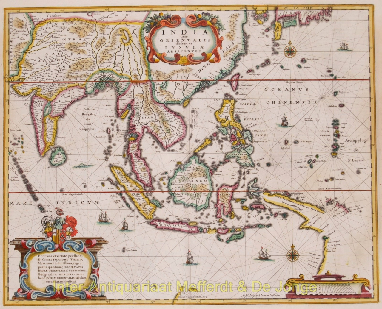
Indiae que Orientalis dicitur, et Insulae Adiacentes, copper engraving first published by Henricus Hondius/Johannses Janssonius [Jansson] in 1636, here from the Atlas Novus edition of 1647. With original hand colouring. Verso: Latin text. Size: 39,8 x 49,2 cm. Henricus Hondius' 1636 map of Southeast Asia was based on Willem Blaeu's map from the previous year. Both maps were vast improvements from earlier maps of the region, and present the extent of the trading influence of the Dutch East India Company. This map features a dedication in Latin to the wealthy Dutch merchant Christophoro Thisio. The map includes Southeast Asia in general with all of Malaysia, the East Indies, the Philippines, Indonesia, Indochina and southern China with the Pearl River Delta, Taiwan, and part of Japan. Unfinished coastlines east and south of Java suggest the unknown lands still to be encountered by Europeans. Here, New Guinea is a long thin island with an open western edge. It is very close to another coastline that we now know is the York Peninsula in Australia. Although De Torres had sailed through the strait now named for him in 1606, the Spanish government suppressed news of the voyage. As a result, mapmakers for over a century would link Australia and New Guinea. Hondius, however, does not quite connect the two here, preferring a cautious approach to the still-mysterious area. There is a note that says that part of the island, known as “Terra d’os Papous” [Land of the Papuans] was named by Jacob le Maire. Le Maire was part of an important voyage from 1615 to 1617. Not only did he and his fellow Willem Schouten (whose name is on an island off the coast of the Terra d’os Papous) circumnavigate the world and name many Pacific islands with Dutch names, they also passed round Cape Horn via a strait that now bears Le Maire’s name. Reference: Koeman's Atlantes Neerlandici, Me 59 Price: Euro 1.850,-