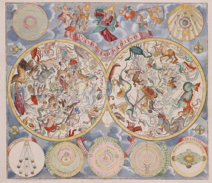
Celestial chart 1750
Matthias Seutter
PapelImprimir
48 ⨯ 57 cm
€ 1.950
Inter-Antiquariaat Mefferdt & De Jonge
- Sobre artePlanisphaerium Coeleste. Copper engraving published by Matthäus Seutter in Nuremberg around 1750. Coloured by a leter hand. Size: 48 x 57 cm. This chart shows us the stars of the Northern and Southern Hemispheres depicted as allegorical figures, animals and scientific instruments. The style of the constellations follows the Firmamentum Sobiescianum sive Uranographia from 1687 by the Polish astronomer Johannes Hevelius. The chart's design was based on work by the Nuremberg astronomer Georg Christoph Eimmart (1638-1705). In addition to the hemispheres, we see seven diagrams against a background of clouds. At the top left texts from Genesis: God called the light "day", and the darkness He called "night". At the top right the phases of the moon as seen from earth. In the center at the top we see God as the Creator, seated on a cloud and accompanied by putti. At the bottom left: the illumination of the moon by the sun, astronomical models by Tycho Brahe, Copernicus and Ptolemy as well as a model by Van Lansberge about the movement of the earth around the sun. A key to the size of the stars on the hemispheres is shown in the center. Price: Euro 1.950,-
- Sobre artista
Matthias Shutter nasceu em 1678 na Alemanha. Ele foi um dos mais importantes e prolíficos editores de mapas alemães do século XVIII. Seutter começou sua carreira como aprendiz de cervejeiro. Aparentemente pouco inspirado pelo negócio da cerveja, Seutter deixou seu aprendizado e mudou-se para Nuremberg, onde se tornou aprendiz de gravador sob a tutela do proeminente J. B. Homann. Em algum momento do início do século 18, Seutter deixou Homann para estabelecer sua própria editora cartográfica independente em Augsburg. Embora ele tenha lutado nos primeiros anos de sua independência, a habilidade de gravura de Seutter e o compromisso com a produção diversificada de mapas acabaram conquistando um número considerável de seguidores. A maioria dos mapas de Seutter foram fortemente baseados, senão cópias de, trabalhos anteriores feitos pelas empresas Homann e Delisle. Em 1732, Seutter era um dos editores mais prolíficos de seu tempo e foi homenageado pelo imperador alemão Carlos VI com o título de “Geógrafo Imperial”. Seutter continuou a publicar até sua morte, no auge de sua carreira, em 1757. A empresa Seutter continuou sob o filho perdulário de Seutter, Albrecht Carl, até sua morte em 1762. Após a morte de Albrecht, a empresa foi dividida entre a firma Probst estabelecida e as emergentes firma de Tobias Conrad Lotter. Lotter, genro de Matthäus Seutter, era um gravador mestre e trabalhava em nome da empresa Seutter. Seutter morreu em 1757.
Você está interessado em comprar esta obra de arte?
Artwork details
Related artworks
Cornelis Anthonisz Theunissen
MUITO RARO PRIMEIRO MAPA IMPRESSO DE AMESTERDÃO, UMA CIDADE EM ASCENSÃO1544
€ 175.000Inter-Antiquariaat Mefferdt & De Jonge
 Com curadoria de
Danny Bree
1 - 4 / 24- 1 - 4 / 24
- 1 - 4 / 24
- 1 - 4 / 12

