Nijmegen 1649
Joan Blaeu
€ 1.450
Inter-Antiquariaat Mefferdt & De Jonge
- Sobre arte
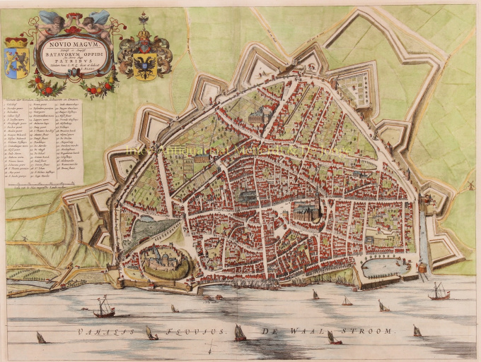
17th century NIJMEGEN "Novio Magum" Copper engraving published in 1649 by Joan Blaeu as part of his famous Toneel der Steden van de Vereenigde Nederlanden met hare Beschrijvingen. Measures 42 x 56 cm. Later hand-coloured. With the outbreak of the Dutch Revolt against Spanish rule in 1568, turbulent times began for Nijmegen as well. In the first phase of the Eighty Years' War, the city was alternately in the hands of Spanish supporters and rebels. In 1591 Prince Maurice 'brought' it back into the camp of the insurgents for good. This so-called Reduction of Nijmegen meant a fundamental change in the political and religious relations in the city. The Calvinists were to set the tone for the coming centuries. All other religious communities were restricted. They were not allowed to practice their religion openly and most professions and public functions remained closed to them for a long time. The economic position of the city changed dramatically. Nijmegen became a garrison town on the eastern border of the Republic of the Seven United Provinces, proclaimed in 1588. Its traditionally strong position in especially the transit trade to its eastern neighbours disappeared. The contacts with the eastern neighbours came to a standstill due to prolonged wars and were not restored. The city was left with only a local and regional trade function. Although there were better and worse times for Nijmegen during the time of the Republic, the city would never regain its former position. 1635 was a particularly dark year. A plague epidemic broke out that, according to tradition, took the lives of six thousand Nijmegen citizens, half of the total city population. Halfway through the seventeenth century there was a short period of economic revival. Nijmegen remained an attractive place of business for publishers, booksellers and printers. (From 1655 to 1680 the city had its own university, the Kwartierlijke Academie, located in the Commanderie van Sint Jan on the Korenmarkt). Price: Euro 1.450,- (incl. list)
- Sobre artista
Joan Blaeu (1596-1673), nasceu em 23 de setembro de 1596 em Alkmaar.
Ele era um cartógrafo holandês nascido em Alkmaar. Ele seguiu os passos de seu pai, o cartógrafo Willem Blaeu.
Em 1620 tornou-se doutor em direito, mas ingressou no trabalho de seu pai. Em 1635 publicaram o Atlas Novus (título completo: Theatrum orbis terrarum, sive, Atlas novus) em dois volumes. Joan e seu irmão Cornelius assumiram o estúdio depois que seu pai morreu em 1638. Joan tornou-se o cartógrafo oficial da Companhia Holandesa das Índias Orientais.
O mapa-múndi de Blaeu, Nova et Accuratissima Terrarum Orbis Tabula, incorporando as descobertas de Abel Tasman, foi publicado em 1648. Este mapa foi revolucionário porque "descreve o sistema solar de acordo com as teorias heliocêntricas de Nicolau Copérnico, que mostram a Terra girando o sol... Embora o livro inovador de Copérnico Sobre as Revoluções das Esferas tenha sido impresso pela primeira vez em 1543, pouco mais de um século antes, Blaeu foi o primeiro cartógrafo a incorporar essa revolucionária teoria heliocêntrica em um mapa do mundo."
O mapa de Blaeu foi copiado para o mapa-múndi colocado na calçada do Groote Burger-Zaal da nova Prefeitura de Amsterdã, projetado pelo arquiteto holandês Jacob van Campen (agora Palácio Real de Amsterdã), em 1655.
A Hollandia Nova de Blaeu também foi retratada em seu Archipelagus Orientalis sive Asiaticus, publicado em 1659 no Kurfürsten Atlas (Atlas do Grande Eleitor). e usado por Melchisédech Thévenot para produzir seu mapa, Hollandia Nova—Terre Australe (1664).
Como "Jean Blaeu", ele também publicou o volume 12 "Le Grand Atlas, ou Cosmographie blaviane, en laquelle est exactement descritte la terre, la mer, et le ciel". Uma edição é datada de 1663. Era fólio (540 x 340 mm) e continha 593 mapas e placas gravadas. Em março de 2015, uma cópia estava à venda por £ 750.000.
Por volta de 1649, Joan Blaeu publicou uma coleção de mapas de cidades holandesas chamada Toonneel der Steeden (Visões de cidades). Em 1651 ele foi eleito para o conselho de Amsterdã. Em 1654, Joan publicou o primeiro atlas da Escócia, elaborado por Timothy Pont. Em 1662 reeditou o Atlas Novus, também conhecido como Atlas Maior, em 11 volumes, sendo um para os oceanos.
Uma cosmologia foi planejada como seu próximo projeto, mas um incêndio destruiu o estúdio completamente em 1672.
Joan Blaeu morreu em Amsterdã no ano seguinte, 1673. Ele foi enterrado no Westerkerk em Amsterdã.
Você está interessado em comprar esta obra de arte?
Artwork details
Related artworks
- 1 - 4 / 12
- 1 - 4 / 24
- 1 - 4 / 12

