Asia  by Jodocus Hondius

Asia 1638 - 1642

Jodocus Hondius

PapierImprimer
45 ⨯ 56 cm
€ 3.450

Inter-Antiquariaat Mefferdt & De Jonge

  • Sur l'oeuvre d'art
    FINE RARE CARTE À FIGURES MAP OF ASIA "Asia recens summa cura delineata Auct. Iud: Hondio". Copper engraving by Jodocus Hondius, published in Amsterdam between 1638-1642 (4th state) by Jan Jansson. With original hand colouring. Verso: German text. Size: 45,5 x 56,5 cm. This highly attractive map embraces all of Asia. The Middle East is very well formed, although the Caspian Sea has the egg-like form it maintained on maps until the 1730s. The Arabian Peninsula is well defined, based on Portuguese sources, and India takes its form after the maps of the Dutch adventurer, Jan Huygen van Linschoten (1596), which, in turn, borrowed from Portuguese sources.  Southeast Asia and the Indonesian Archipelago are derived from charts made for the Dutch East India Company (VOC), while China is derived from Jesuit sources, although Korea is an oddly elongated peninsula. The geography of the region would remain an enigma to Europeans until the early 18th Century.  Japan's Honshu and Kyushu are recognizable, although the area further to the northeast remains a vast mystery. True to the carte à figures' style, which was the hallmark of the great contemporary period of Dutch Baroque cartography, the map is surrounded on four sides by registers of fine vignettes. Along the top of the map are views of Famagusta (Cyprus), Rhodes (Greece), Damascus, Jerusalem, Aden and Hormuz (Persia).  Along the left side of the map are depictions of people in local costume including Syrians, Arabs, Armenians & Persians, Indians, and Sumatrans.  On the right side are depictions that include Javanese, Moluccans & Bandans, Chinese, Russians and Tartars. Along the bottom of the map there are further town views of Dutch trading posts Goa (India), Calcutta (Bengal/India), Kandy (Ceylon), Bantam, Gammalamme (Moluccas) and Macao. In addition the map is embellished by a fine title cartouche and ships and sea monsters in the seas. The map was originally conceived by Jodocus Hondius the Younger (1594-1629), whose eponymous father played a large part in the rise of Amsterdam as the dominant cartographic production centre in the 17th Century. The present edition of the map is by Jan Jansson (1588-1664), who married Jodocus the Younger's sister Elizabeth.  He transformed the Hondius firm into a powerhouse of geographical publications. Jansson most notably published the Atlas Novus (1638), and the Atlas Major (1660), the 11 volumes of which included a town atlas, a hydrographic atlas, an atlas of the ancient world, and Andreas Cellarius' incomparable celestial atlas.  Jansson's works were rivalled only by those of his arch-nemesis Joan Blaeu. The present map is one of the finest depictions of Asia from the apogee of Dutch cartography. Price: Euro 3.450,-  
  • Sur l'artiste

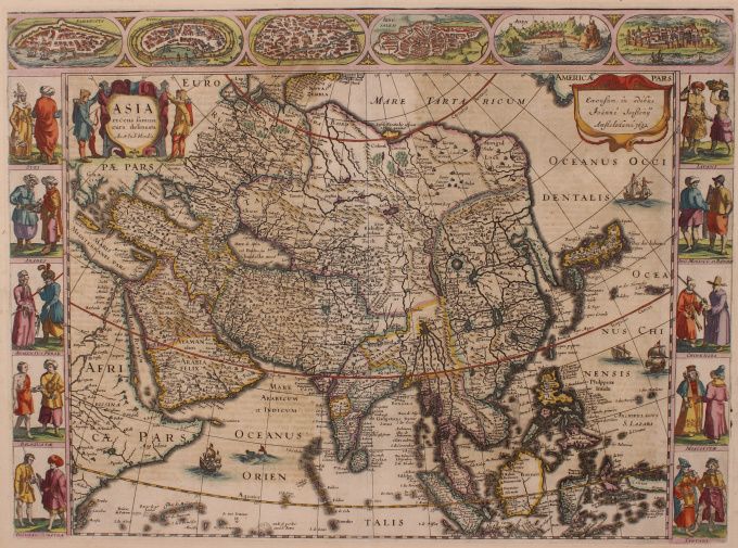
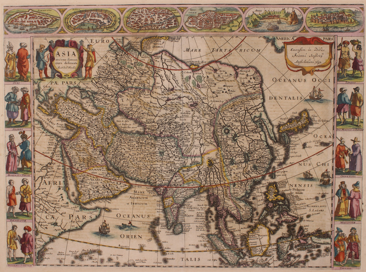
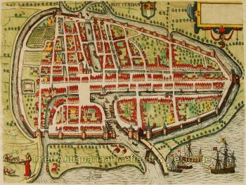
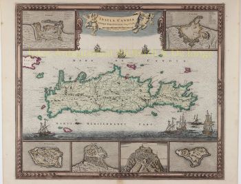
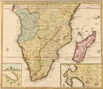
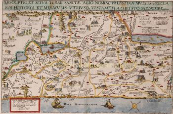
    Jodocus Hondius (17 octobre 1563 – 12 février 1612), également connu sous la forme latinisée de son nom néerlandais Joost de Hondt, était un graveur et cartographe flamand, figure emblématique de l'âge d'or de la cartographie néerlandaise. Pour le distinguer de son fils, on le désigne souvent sous le nom de Jodocus Hondius l'Ancien.

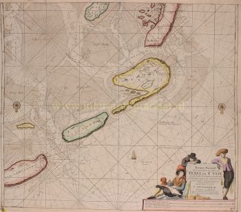
    Hondius s'est illustré par son talent exceptionnel à allier maîtrise technique de la gravure et érudition géographique. Il est surtout connu pour ses premières cartes, qui ont joué un rôle déterminant dans la compréhension visuelle des territoires nouvellement explorés en Europe au tournant du XVIIe siècle. Ses cartes se caractérisent par leur clarté, leur précision et la richesse de leurs détails décoratifs, qualités qui en ont fait à la fois des documents scientifiques de référence et des œuvres d'art très recherchées.

    Un moment charnière dans la carrière de Hondius fut l'acquisition des plaques d'impression originales de Gerardus Mercator. À une époque où la réputation de Mercator commençait à décliner, Hondius republia et enrichit ces planches, y intégrant ses propres corrections et les nouvelles connaissances géographiques disponibles. Cet acte permit non seulement de raviver l'héritage de Mercator, mais aussi d'assurer son influence durable, donnant naissance aux célèbres atlas Mercator-Hondius qui dominèrent la cartographie européenne pendant des décennies.

    Outre son talent de cartographe, Hondius était également un graveur de portraits accompli. Ses portraits de Francis Drake figurent parmi les représentations visuelles les plus reconnaissables du célèbre navigateur anglais, témoignant de sa polyvalence et de son rayonnement culturel.

    Figure centrale de l'âge d'or de la cartographie néerlandaise (vers 1570-1670), Hondius joua un rôle crucial dans l'établissement d'Amsterdam comme principal centre de la cartographie en Europe au XVIIe siècle. Son œuvre, à la croisée de l'art, de la science et du commerce, façonna la manière dont le monde était cartographié, compris et imaginé. Aujourd'hui, Jodocus Hondius l'Ancien est reconnu comme un maître graveur, un éditeur novateur et un architecte clé de l'histoire de la cartographie moderne.

Êtes-vous intéressé par l'achat de cette oeuvre?